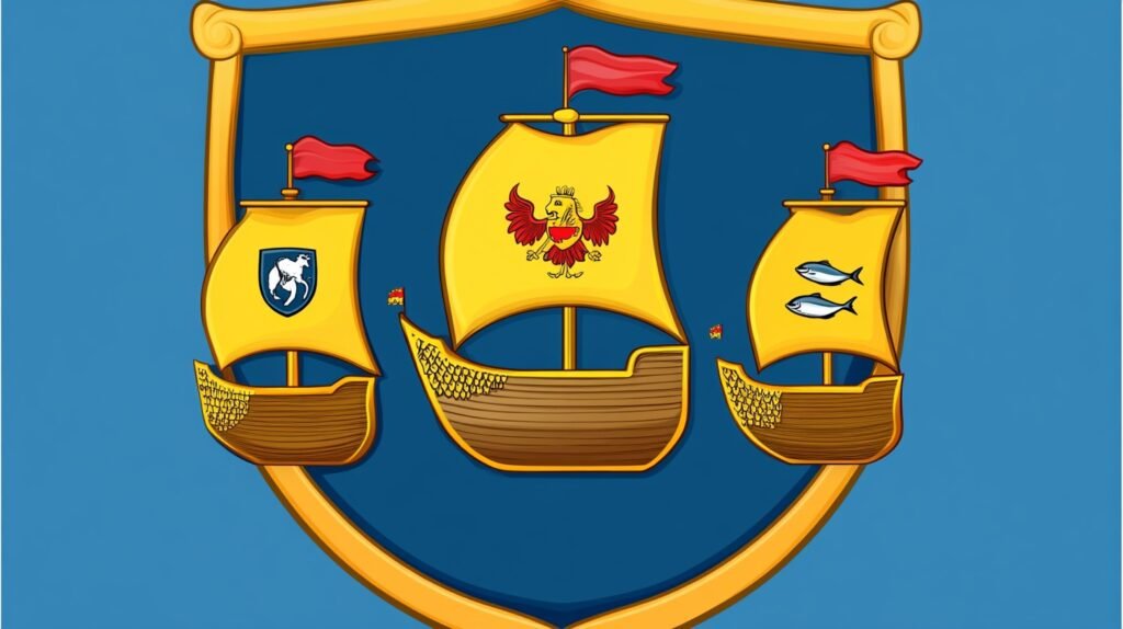
Coat of Arms of Kreis Nordfriesland
- Design: The coat of arms features three golden, three-masted ships from the 16th century, arranged in a 2:1 formation. The ships have golden sails and red pennants. Each of the main sails bears a red emblem:
- 1st ship: A plow (representing the former Husum district).
- 2nd ship: A fish (representing the former Südtondern district, specifically the “Sylt herring”).
- 3rd ship: A bull’s head (representing the former Eiderstedt district, known for its cattle farming).
- Historical Background:
- The design is based on the seal of the former “Landschaft” Eiderstedt, which dates back to 1613. This seal symbolized the unity of the three regions (Harden) of Eiderstedt, Everschop, and Utholm, as well as their connection to shipping and trade.
- The current coat of arms was approved on July 10, 1972, and was designed by W. H. Lippert from Brunsbüttel.
- The Kreis Nordfriesland was formed in 1970 through the merger of the former districts of Eiderstedt, Husum, and Südtondern.
- Symbolism:
- The three ships represent the unity of the three historical regions.
- The emblems on the sails (plow, fish, and bull’s head) symbolize the former districts that make up the modern Kreis Nordfriesland.
- The colors (blue, red, and gold) are derived from the popular 19th-century North Frisian landscape coat of arms, which also featured a half-eagle, a crown, and a porridge pot.
Key Differences from Historical Seals:
- The original Eiderstedt seal showed the ships in a 1:2 formation, and the emblems were placed on the ship hulls rather than the sails.
This coat of arms is rich in historical and regional symbolism, reflecting the maritime and agricultural heritage of Nordfriesland.
The North Sea Coast of Schleswig: A Tapestry of History & Nature
History
The North Sea coast of Schleswig-Holstein, encompassing areas like the island of Sylt and the mainland around Husum, boasts a history shaped by its maritime environment and strategic position. Archaeological evidence points to settlement as early as the Mesolithic period (around 9600–4000 BCE), with hunter-gatherers drawn to the coastal resources. By the 1st century CE, Germanic tribes like the Frisians inhabited the marshlands, adapting to the tides with “Wurten” (artificial mounds) to survive storm surges. The region’s medieval history is marked by its incorporation into the Duchy of Schleswig and the influence of the Hanseatic League, which tied coastal towns into broader trade networks.
Sylt’s history diverges with Frisian roots, its inhabitants historically resisting feudal control and maintaining a rugged independence bolstered by fishing and seafaring. The island faced Danish rule from the 14th century until the Second Schleswig War of 1864, when it passed to Prussia, cementing its German identity. Husum, meanwhile, emerged as a trading hub by the 14th century, granted town rights in 1601, and became known as the “grey town by the sea” due to its slate-roofed houses—a moniker immortalized by poet Theodor Storm. Both areas endured the region’s vulnerability to North Sea floods, notably the devastating Grote Mandrenke of 1362, which reshaped coastlines and spurred dike-building traditions that persist today. The 19th and 20th centuries saw modernization, with railways and tourism transforming the region’s cultural and economic fabric.
North Sea Coast
The North Sea coast of Schleswig-Holstein stretches from the Elbe River to the Danish border, encompassing dramatic landscapes like Sylt’s windswept dunes and the mainland’s marshy expanses. Sylt, the northernmost German island, is famed for its 40 kilometers of beaches—white sands on the west, rugged cliffs like the Morsum Kliff on the east—and the Hindenburgdamm, a causeway built in 1927 linking it to the mainland. Its exposed position amplifies its wild beauty, with crashing waves and shifting dunes sculpted by constant winds. The Wadden Sea, a UNESCO World Heritage Site spanning the coast, offers tidal flats teeming with wildlife—seals, migratory birds like oystercatchers—and opportunities for “Wattwanderung” (mudflat hiking), a signature experience.
Westerland (Sylt)
Westerland, Sylt’s largest town and de facto capital, is a vibrant seaside resort with around 9,000 residents. Born from the merger of smaller villages in 1897, it gained prominence with the arrival of the railway via the Hindenburgdamm, transforming it into a tourist magnet by the early 20th century. Its beachfront promenade, lined with colorful Strandkörbe (hooded wicker beach chairs), stretches along the roaring North Sea, while the Sylter Welle leisure pool offers indoor respite. Westerland’s architecture blends modern hotels with traditional Frisian thatched-roof houses, reflecting its dual identity as a luxury getaway and cultural preserve.
The town hosts events like the Windsurf World Cup, drawing international crowds, and its nightlife—bars, casinos, and fine dining—caters to a cosmopolitan clientele. Culturally, the Sylt Local History Museum explores the island’s maritime past, while landmarks like the St. Niels Church (built 1908) add historical depth. Westerland’s economy hinges on tourism, with property prices among Germany’s highest, underscoring its status as an elite retreat.
Husum’s coast, by contrast, is more subdued, with dikes protecting fertile marshes and a small harbor that once bustled with trade but now serves leisure boats and shrimp cutters. The region’s weather—bracing winds, frequent storms—defines its character, while its ecological significance draws conservationists and tourists alike. Coastal protection remains a priority, with dikes and groynes guarding against erosion and rising sea levels, a modern echo of centuries-old resilience.
Husum (mainland)
Husum, a mainland town of about 23,000, lies 40 kilometers south of Sylt and exudes a quieter charm. Known as the birthplace of Theodor Storm (1817–1888), whose novella The Rider on the White Horse evokes the region’s stormy soul, Husum celebrates its literary son with the Theodor-Storm-Haus museum. Its harbor, framed by grey-shingled houses, buzzes during the annual Krabbentage (Crab Days) festival, spotlighting local seafood. The Schloss vor Husum, a 16th-century castle surrounded by crocus blooms in spring, anchors the town’s historical allure.
Husum’s economy balances tourism with industry, notably wind energy, while its weekly market and quaint streets draw day-trippers. The Marienkirche, a Gothic brick church from the 19th century, and the nearby NordseeMuseum, detailing coastal life, enrich its cultural offerings. Though less glamorous than Westerland, Husum’s authenticity and proximity to the Wadden Sea make it a beloved gateway to the North Sea coast.
Economic Landscape
The economy of this North Sea region blends tradition with innovation. Agriculture thrives on the mainland, with Husum’s surrounding marshes supporting dairy farming, root crops, and the famed Nordsee shrimp fishery, a cultural and culinary staple. Sylt, less suited to farming due to its sandy soil, historically relied on fishing and whaling, though these have largely given way to tourism. The island now generates significant revenue as a premium resort destination, its high-end hotels and restaurants catering to affluent visitors from Germany and beyond.
Renewable energy is a growing force, particularly wind power. Schleswig-Holstein leads Germany in wind energy production, with turbines lining the coast and offshore farms harnessing North Sea gusts—Sylt hosts some, though their visual impact sparks debate among locals valuing pristine vistas. Husum has positioned itself as a hub for the wind industry, hosting trade fairs like “Husum Wind” and companies specializing in turbine technology. Maritime trade, once central to Husum’s prosperity, has diminished, but the port still supports small-scale fishing and logistics. Tourism, however, dominates, fueled by the coast’s natural allure and cultural heritage, employing thousands and sustaining local businesses year-round.
Top 3 – Nord-Friesland
- Sylt
This island’s the rockstar of Nordfriesland—long, skinny, and lashed by the North Sea. Connected by the Hindenburgdamm causeway, it’s a mix of posh resorts and wild beauty. The dunes around List and Hörnum are towering and raw, with waves crashing on one side and the Wadden Sea’s calm on the other. Kampen’s red cliffs and thatched-roof houses scream postcard vibes, while the Ellenbogen spit feels like the edge of the world. It’s got a rep for fancy crowds, but the nature’s what hooks you—wind, sand, and seabirds everywhere. - Hallig Islands (Halligen)
These tiny, low-lying specks in the Wadden Sea are something else—ten of them, barely above sea level, where storms sometimes flood everything but the houses perched on artificial mounds (Warften). Nordstrandischmoor or Hooge are good bets to visit—small enough to walk in an hour, with salt marshes and sheep grazing like it’s the 17th century. You get there by ferry or, if tides align, a muddy trek across the seabed. It’s eerie and serene, a glimpse of a life shaped by the sea’s whims. No flash, just pure, quiet survival. - St. Peter-Ording
Mainland Nordfriesland shines here, with a beach that’s absurdly wide—up to two kilometers at low tide—and framed by stilted houses (Pfahlbauten) that look like they’re tiptoeing over the sand. It’s a kite-surfing and windsurfing mecca thanks to the relentless North Sea breezes, but even if you’re not riding waves, the dunes and pine forests behind it are a draw. The salt meadows nearby bloom purple in summer, and the sunset over the water’s a slow burn you won’t forget. It’s got a laid-back buzz, less polished than Sylt but just as striking.
Bonus Tip – An Under the Radar Destination: Wyk auf Föhr
Wyk auf Föhr, a little seaside town on the island of Föhr, isn’t as flashy as Sylt or as remote as the Halligen, but it’s a North Sea treasure. Tucked away from the mainland hustle, it’s got a sandy beach that curves along the coast—rare for these parts—and a promenade lined with colorful beach huts. The town’s Frisian roots run deep; you might catch locals chatting in Fering, their dialect, over a coffee. It’s sleepy, sure, with a handful of cafes and a small maritime museum, but that’s the draw—peace, sea air, and a ferry ride from Dagebüll that feels like a mini adventure. Spring or summer’s best, when the island blooms and the water’s warm enough to dip a toe.